


la chapelle vassieux en boucle

aldaus
User
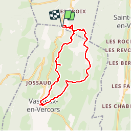

Length
16.1 km

Max alt
1121 m

Uphill gradient
263 m
Km-Effort
19.6 km

Min alt
1032 m

Downhill gradient
262 m
Boucle
Yes
Creation date :
2019-09-29 08:05:45.314
Updated on :
2019-09-30 05:24:07.745
5h01
Difficulty : Very easy

FREE GPS app for hiking
 SityTrail
IGN / Geographical institutes
SityTrail Plus
The world is yours!
About
Trail Walking of 16.1 km to be discovered at Auvergne-Rhône-Alpes, Drôme, La Chapelle-en-Vercors. This trail is proposed by aldaus.
Positioning
Country:
France
Region :
Auvergne-Rhône-Alpes
Department/Province :
Drôme
Municipality :
La Chapelle-en-Vercors
Location:
Unknown
Start:(Dec)
Start:(UTM)
688111 ; 4978236 (31T) N.
Comments